
For this:
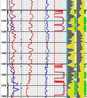
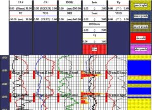
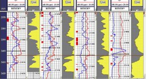
Processing and interpretation of GGT data
Aquifer, clay, mineralization, porosity of produced water
Determination of current oil and gas saturation
Determination of percentage of watering in accordance with INC
Locating contact fluid
Petrophysical support for the quantitative interpretation of GGT data in order to predict reservoir saturation zones and calculation parameters
Automated based on the justification of the geological model of the layer
Possibility of data processing on the system
Inclusion of user interpretation methods in computer processing of GGT data based on the results of interpretation of GGT data or interpretation of GGT data based on a generalized algorithm, construction of a lithological and filtration model of rocks in the interval of interest over the entire section
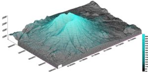
Construction of lithological and fluid sections on profiles in the area of geological objects of interest:
Complete lithofascial analysis of rock layers
The definition of the boundaries of the facial sequence of rocks
Correlation of stratigraphic boundaries of rocks with facies
As a result of the analysis, the system of profiles, the shape of the geological body, the process of sedimentation, the formation of deposits, for example, the formation of the paleo-river direction, are described, and the formation of water bodies can be determined. Based on the information received, the boundaries of the cross section of hydrocarbon deposits are determined and a three-dimensional geological model of the field is built (Integral Field).
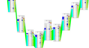
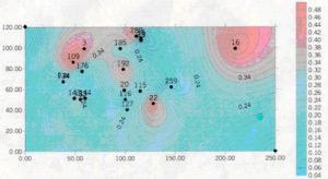
Building a map of the distribution of facies on the ground.
The information obtained as a result of interpretation and processing of GGT data is used to solve other key geological problems:
Preparation of an operational opinion on well drilling
Determination of parameters used in the development of a field development project and in calculating reserves.
Monitoring the process of hydrocarbon production from oil and gas fields.
Construction of a geological model of the entire field and individual layers based on the results of the interpretation of various geological information, QGT data
Selection and geological substantiation of points for well placement
Exploration work in conjunction with the process of developing oil and gas fields and geological and geophysical